|
HISTORY OF THE CHEROHALA SKYWAY
Checkout www.tailofthedragon.com |
||
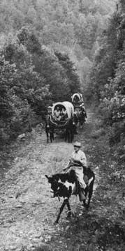
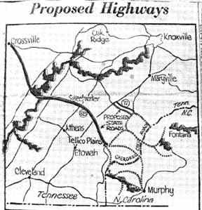
By Ronald E. Johnson The dream of the Cherohala Skyway began in 1958. Television was America's new brand of entertainment and the wild west was a Hollywood staple. Gun Smoke and Wagon Train captured weekly television audiences. Wagon Train, dramatizing the settling of the American frontier, was a favorite show of Sam Williams. Williams dreamed of his own modern-day wagon train from his home in Tellico Plains to the Unakas of North Carolina. He brought up his idea, jokingly, at the Kiwanis Club meeting in the spring of 1958. At that time there were roads that joined the two locations but were only fit for covered wagons. After some laughter, the idea started to take a serious tone and Williams’ Wagon Train Road was born. Six weeks after the original idea, sixty-seven covered wagons and over three hundred horseback riders gathered at the Tennessee - North Carolina state line to make history. This first Wagon Train traveled to Murphy, North Carolina. Local politicians loved the idea and it would eventually evolve into the construction of a highway between Tellico Plains and Western North Carolina. The success of the first wagon train took the organizers by surprise. Promotion of the highway was important, but the experience of an authentic wagon train was the real reason it became an annual event. Efforts to assure the construction of a highway from Tellico Plains to Western North Carolina took a turn in late 1962. The original route from Tellico Plains to Murphy was not feasible. It was discovered that a highway between Tellico Plains and Robbinsville could be constructed entirely on federal land. Robbinsville was the only Western North Carolina town to which such a route was possible. Late in 1962, congress made the first funding allocation for the new highway. After 100 million dollars and thirty-four years, the Cherohala Skyway was official opened in October 1996. It still took another year to actually complete the North Carolina side. The US Forest service estimated that five million cars a year would use the new road. This figure, which calculates to 10 cars a minute year-round, was extremely unrealistic. The actual average figure today is more like ten cars and fifty motorcycles a day. In the winter months the Cherohala sees very little traffic. Yet we have seen some of the most spectacular scenes high on the “wagon train road” in the coldest months. Despite efforts to keep it salted and plowed the road surface can still be treacherous. It is no place to be caught by a sudden snowstorm. So venture onward with caution from December to April. The first few years the road was open, traffic was minimal with only the locals and a few well-informed vacationers reaping the rewards of North Carolina’s most expensive highway. In recent years, due to the Internet and advertising, the Cherohala has become a popular destination for sightseers in cars, adventure seekers on motorcycles, and even hardy bicyclists. The Cherohala (pronounced chair-o-hey-la), a combination of Cherokee and Nantahala, begins on the North Carolina side at Santeetlah Gap with an elevation of 2,660 feet. It them climbs to it highest point 5,390 feet at Santeetlah Overlook in just eleven miles. Another few miles and you are at the Tennessee State Line and descending towards Tellico Plains at 920 feet elevation. The total length is fifty-two miles and encompasses scenery from deep forests to mountaintop vistas. Stops of interest on the North Carolina side include Joyce Kilmer Memorial Forest, pull-offs with views of Stratton and Haoe Balds, hiking trail to Huckleberry and Strawberry Knobs, Hooper Bald Trail, Santeetlah Overlook, Big Junction with views into the Cherokee National Forest, and Unicoi Crest with views of wilderness areas both east and west. As you descend on the Tennessee Side several overlooks offer mountain views; Brushy Ridge, Lake View, and Turkey Creek. Indian Boundary Campground is open April through September and offers camping. Just a few miles off the Cherohala is the scenic Tellico River where you will find Bald River Falls and the Tellico Ranger Station. Many motorcyclists and sports car drivers prefer the Cherohala to other area roads because of its scenery, higher elevations, and sweeping curves. It is a completely different ride from the popular Tail of Dragon that has much tighter corners and little scenery other than forest. Many visitors include both the Cherohala and the Tail of the Dragon in a 120-mile loop that takes most of the day to complete if you include scenic stops and meals. Remember that there is a big elevation difference here – some 4,300 feet, so the temperatures can vary widely. Take something warmer to put on for the mountain crossing. There are bathroom facilities at several of the pull-offs, but be sure to have enough fuel to make the 60-mile trip. There are no gas stations along the way. Take your lunch and stop at one of the scenic picnic areas. |